Urban buildings were not created in isolation, but reflected the community within which they were constructed. Organisations and individuals who could afford new buildings did so not simply for their own satisfaction and comfort, but as a statement in the townscape, an expression of self-confidence, whether personal or civic. By the later eighteenth century buildings, and indeed whole streets and areas, were statements of fashion, style and modernity in a fast-changing world.
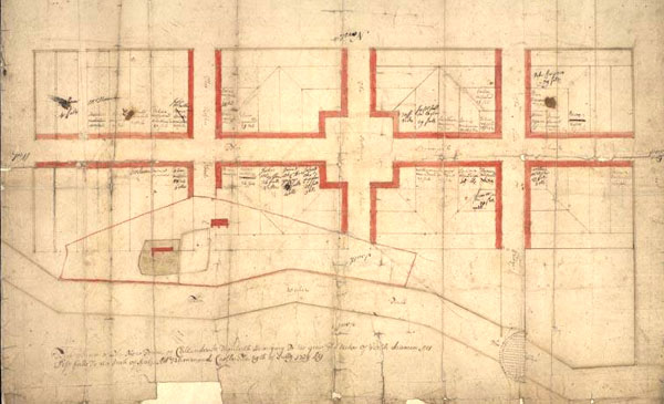
Feuing plan of the new town
of Callender in Menteith, the property of the Duke of Perth, drawn in
1739.
© SCRAN/National
Archives of Scotland
Mediaeval burghs had been laid out with
simple but generous plans, and most did not fill up all their vacant
plots until well into the eighteenth century. When they did, and there
grew up a demand for housing outside the town centre, grid-plan suburbs
tended to be developed. Normally a landowner would decide that he could
get more money from feuing land for housing than he could by continuing
to let it out for agricultural purposes.* Streets were laid out, and
plots defined along them. These plots were then sold, usually by auction,
and with restrictions on the type of building, minimum sizes and materials,
and the line of the street frontage. Sometimes a developer built whole
streets to a standard design. In other cases, a mason might buy a few
plots, build a group of houses, keep one to live in and sell the rest.
* Feuing is a Scottish form of
leasehold whereby the purchaser pays a lump sum of a fixed number of
years' rent, then continues to pay an annual rent, but the tenancy is
for life, and can be sold or inherited. As the rent or 'feu duty' was
fixed, the effect of inflation was to make feuing in the long term little
different from freehold purchase.
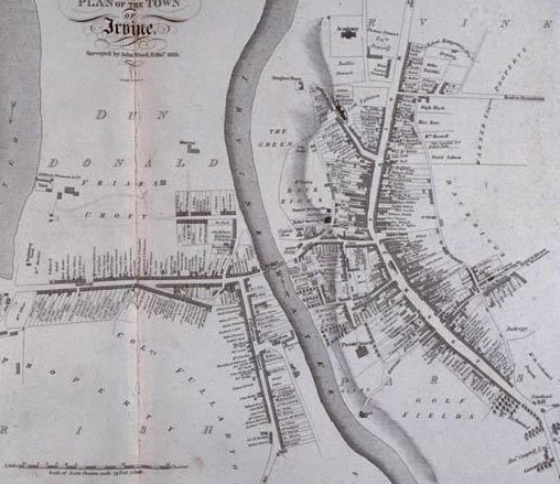
Town plan of Irvine, 1819, surveyed by
John Wood (c.1780-1847). The old town stands on the east side of the
river, with the academy in 'an airy situation' at the north end. To
the west is the newer burgh of barony of Fullarton, connected to Irvine
by 'a handsome stone four-arched bridge' built in 1746.
©
SCRAN/National Library of Scotland
The more ambitious or self-conscious town
councils took some initiative in founding or encouraging such ‘new
towns'. A new wide, clean, symmetrical street, for example, might serve
as a more impressive entrance to a town than an irregular older one. New
town developments included Keith (c.1750), Langholm (1778), Kilmarnock
(1820) and Cullen (1821). Occasionally, as at Cullen, the new town replaced
rather than extended the older burgh.
Some new towns were quite simple, and some contained a mix of industrial and residential development. But they all served to change the way the burgh worked. Those living and working outside the old boundary did not pay taxes, and new markets grew up outwith the control of the old closed shops of guildry and trades, which were becoming increasingly irrelevant.
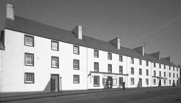
The new town of Inveraray was founded in
1743. This block, called Arkland, was designed by Robert Mylne, and constructed
in 1774-5.
© SCRAN/RCAHMS
As suburbs grew, and industries moved
out, town centres could be given a facelift. As well as rebuilding town
house and church, many burghs took the opportunity to demolish derelict
buildings, remove forestairs, widen streets, and then keep them cleaner
and better lit.
At the core of these developments were two
professions, the architect and the surveyor. Architects had existed for
a while, but during the eighteenth century numbers in the profession grew,
and a clearer distinction evolved between architect and builder. What
little accurate survey work had been needed had until the eighteenth century
had been done by estate factors or schoolmasters. During the century the
profession of surveyor grew up, to lay out new roads and new towns, adding
to an expanding professional middle class.
| Next | ||