|
TARANIA /
Insula in aestuario Glottae /
THE YLE OF
ARREN / in the Fyrth of Clyd / Timotheo Pont Auctore.
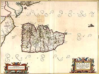
The
map shows Arran, with the adjacent coasts of Kintyre and Bute. It
also shows Ailsa Craig which necessitates the orientation with west
at the top.
Dense settlement all around the coasts is evident, with only Brodick
Castle depicted with any prominence. The more mountainous north
of Arran is clearly indicated in the perspective drawings.
The map was compiled from observation on the ground by Timothy Pont,
in the last two decades of the sixteenth century. It was engraved
in Amsterdam, for publication in Blaeu's Atlas Novus, first published
in 1654.
SCRAN ID: 000-000-184-424-C; University of Edinburgh - Department
of Geography
|