Tertiary
65-2.4 Ma ( Arran at 51-55.5 degrees North)
Nearly half
of the surface area of Arran consists of Tertiary igneous rocks; if superficial
drift is ignored. The rugged scenery of the island is dominated by the
granite in the north. This granite is the root of an old volcano intruded
into the country rocks during the Lower Tertiary as a result of increased
igneous activity linked with rifitng and the opening of the North Atlantic
between Greenland and Scotland.
This period of increased mantle heat flow and associated igneous activity
has left a suite of rocks known as the British Tertiary Province. Located
roughly at the center of the Province, Arran was subjected to the volcanic
activity which would see the creation of a chain of volcanoes from Skye
to Ailsa Craig.
 Lasting
a only a couple of million years, this volcanic activity has had a major
impact on the topography and geomorphology of Arran. Namely, the proud
and jagged peaks of the north owing their lofty existence to the granite’s
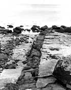
capacity to resist weathering, and the spectacular crustal extension demonstrated
by the out-weathered basic dyke swarms found in the south at Kildonan. Lasting
a only a couple of million years, this volcanic activity has had a major
impact on the topography and geomorphology of Arran. Namely, the proud
and jagged peaks of the north owing their lofty existence to the granite’s
capacity to resist weathering, and the spectacular crustal extension demonstrated
by the out-weathered basic dyke swarms found in the south at Kildonan.
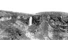
The Central Ring Complex of Arran is also a feature of the igneous activity.
It is the remains of a collapsed volcano caldera and the volcano’s
exposed ancient roots. Furthermore, the island is covered with many basic
and felsic sheets and sills. These have been intruded into the country
rock, especially exploiting the weaknesses along the bedding planes of
the gently dipping Triassic rocks in the south, to form significant cliff
features seen at the Holy Island, Plada and Drumadoon.
|