Rome’s most enduring legacy is her roads which, along with shipping
routes and rivers, provided the empire with a communications network unsurpassed
until modern times. Even today many roads still follow the courses of
their Roman predecessors. In Scotland, the Roman roads were exclusively
military, linking together forts and frontier systems.
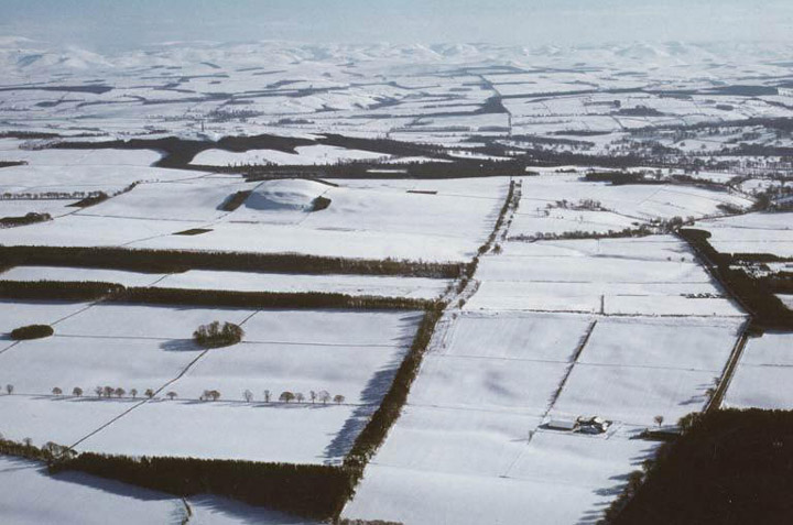
The line of Dere Street, revealed by
later field boundaries and tracks.
© SCRAN/J Dent/Borders Council
The course of a Roman road is often revealed by the later roads, tracks,
or field boundaries which have followed it. Here the line of Dere Street,
Rome’s main route into Scotland, is clearly seen emerging from the
snow-covered northern foothills of the Cheviots, heading towards the Forth.
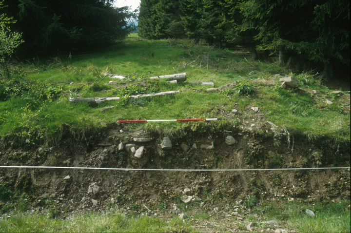
The road along the Gask
Ridge is visible here as a heavily cambered mound,
or agger, running through a gap in the trees. In the foreground a cross-ditch
has exposed some of the stone bottoming. Originally the road would have
been surfaced with gravel, and a steep camber was necessary to reduce
erosion by throwing off surface water.
© Colin Martin
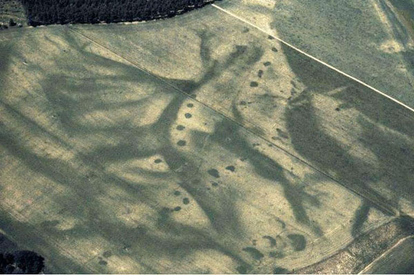
Even where the remains of
a Roman road have been destroyed by ploughing, quarry-pits dug beside
them to provide material for their construction sometimes show as crop-marks.
Here, at Wester Drumatherty some 2 km north-west of the legionary fortress
at Inchtuthil, crop-marks identify a junction of two Roman roads. One
is apparantly heading towards the sandstone quarries on Gourdie Hill,
while the other follows a level contour into an adjacent valley, perhaps
to facilitate timber extraction.
© SCRAN/RCAHMS
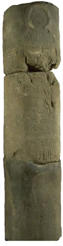
The only Roman milestone known in Scotland (right)
was found near Ingliston in the seventeenth century. It is now in the
National Museum of Scotland. Though fragmentary, its text can be restored
to incorporate the name and titles of Antoninus Pius, probably (though
not certainly) at the time of his third consulship, in 140-44. The stone
records an unknown number of miles to Trimontium
(Newstead), and was set up by the First Cohort of Cugerni. Of particular
interest is the fact that two lines have deliberately been erased. This
part of the inscription would almost certainly have included the name
of the provincial governor, and the erasure indicates his official disgrace.
It can hardly have been Lollius Urbicus, the governor of Britain under
Antoninus Pius recorded as ‘driving back the barbarians’ and
‘building another wall, of turf’ (the Antonine Wall), for
he went on to complete a distinguished and unblemished career. His successor
is not known, but a possible candidate is Cornelius Priscianus who, in
145, was disgraced for misdemeanours while governor of part of Spain.
© SCRAN/National Museums of Scotland