|
Landscapes
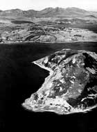
  Geology
determines the landscape to a large extent. The nature of the underlying
rock determines how it responds to various geological processes that are
active at the surface of the Earth. At the most basic level, rocks which
are hard and hence more resistant to weathering tend to stand out above
rocks that are softer and more prone to weathering. A good example on
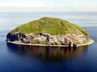
Arran is granite, which forms the high peak of Goat Fell in the north
(shown on the left), and also the small island of Ailsa Craig off the
south coast of Arran (pictured on right). Geology
determines the landscape to a large extent. The nature of the underlying
rock determines how it responds to various geological processes that are
active at the surface of the Earth. At the most basic level, rocks which
are hard and hence more resistant to weathering tend to stand out above
rocks that are softer and more prone to weathering. A good example on
Arran is granite, which forms the high peak of Goat Fell in the north
(shown on the left), and also the small island of Ailsa Craig off the
south coast of Arran (pictured on right).
  Soft
rocks weather rapidly and form rich soils, hard rocks are obviously more
resistant, and produce less soil. This fundamental relationship is seen
all across Arran, and a good example is along the southern coast where
the hard resistant dykes stand out above the much softer sandstones into
which they were intruded. The tidal zone shows this clearly, with swarms
of dykes being visible (as demonstrated in the picture on the right).
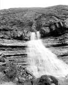
Inland, resistant sills often give rise to waterfalls such as at Auchenhew.
Another good example if this is shown on the left at Levencorroch Burn
(shown on left), where a relatively hard and resistant dolerite sill produces
another waterfall as it prevents the erosion by water of the much softer
Triassic sandstones beneath it (the description of the larger image explains
how the waterfall forms). Soft
rocks weather rapidly and form rich soils, hard rocks are obviously more
resistant, and produce less soil. This fundamental relationship is seen
all across Arran, and a good example is along the southern coast where
the hard resistant dykes stand out above the much softer sandstones into
which they were intruded. The tidal zone shows this clearly, with swarms
of dykes being visible (as demonstrated in the picture on the right).
Inland, resistant sills often give rise to waterfalls such as at Auchenhew.
Another good example if this is shown on the left at Levencorroch Burn
(shown on left), where a relatively hard and resistant dolerite sill produces
another waterfall as it prevents the erosion by water of the much softer
Triassic sandstones beneath it (the description of the larger image explains
how the waterfall forms).
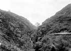
   Perhaps
the biggest influence on the present day landscapes of Arran has been
the Pleistocene ice-ages. In geological terms, the last ice-age happened
very recently (i.e. 18,000 years ago) so it is not surprising that the
landscapes of Arran so strikingly reflect the dramatic modifications produced
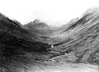
by thick glaciers and ice-sheets. Valleys, such as Glen Rosa, have been
gouged out by glaciers in the characteristic U-shape; clearly the tiny
stream now present did not cut this beautiful valley. Apart from gouging
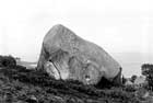
out valleys, the ice was also responsible for moving large blocks of rock
- the so-called 'eratics' that are visible in many parts of Arran (image
on right). Perhaps
the biggest influence on the present day landscapes of Arran has been
the Pleistocene ice-ages. In geological terms, the last ice-age happened
very recently (i.e. 18,000 years ago) so it is not surprising that the
landscapes of Arran so strikingly reflect the dramatic modifications produced
by thick glaciers and ice-sheets. Valleys, such as Glen Rosa, have been
gouged out by glaciers in the characteristic U-shape; clearly the tiny
stream now present did not cut this beautiful valley. Apart from gouging
out valleys, the ice was also responsible for moving large blocks of rock
- the so-called 'eratics' that are visible in many parts of Arran (image
on right).
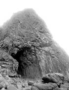  The
action of the sea on rocks also exploits some of their geological properties.
The image on the left shows Black Cave on Arran, a modern sea cave cut
into relatively hard columnar jointed lavas, where the weaknesses present
along the joints has been exploiting by the action of the sea to produce
a relatively tall but narrow cave aligned along the jointing direction.
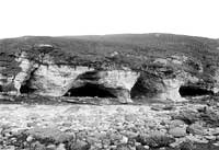
On the left is an image of King's Cave, in which relatively wide caves
have been cut in much softer Triassic sandstones. Note also that King's
Cave is a fossil - it was cut when the sea was around 10 metres higher
that its current level. This was another prominent feature of the landscape
on Arran produced by the relatively recent glaciation. The enormous weight
of the ice pushed the land down ( a pheonomenon known as isostacy). At
the end the ice-age the ice melted much more rapidly that the land could
rebound, and so the sea was at a much higher level once the ice had gone.
Since that time, Arran has been slowly rising again due to isostacy, and
hence the early post-glacial coastline is now much higher up the coastline.
Where ever you go on the coastline of Arran, keep your eyes peeled for
the evidence of these massive land movements. The
action of the sea on rocks also exploits some of their geological properties.
The image on the left shows Black Cave on Arran, a modern sea cave cut
into relatively hard columnar jointed lavas, where the weaknesses present
along the joints has been exploiting by the action of the sea to produce
a relatively tall but narrow cave aligned along the jointing direction.
On the left is an image of King's Cave, in which relatively wide caves
have been cut in much softer Triassic sandstones. Note also that King's
Cave is a fossil - it was cut when the sea was around 10 metres higher
that its current level. This was another prominent feature of the landscape
on Arran produced by the relatively recent glaciation. The enormous weight
of the ice pushed the land down ( a pheonomenon known as isostacy). At
the end the ice-age the ice melted much more rapidly that the land could
rebound, and so the sea was at a much higher level once the ice had gone.
Since that time, Arran has been slowly rising again due to isostacy, and
hence the early post-glacial coastline is now much higher up the coastline.
Where ever you go on the coastline of Arran, keep your eyes peeled for
the evidence of these massive land movements.
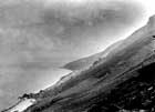
  So
although the ice has gone, there is ample evidence of its former presence
on Arran, in the form of the raised beaches. There might be even more
specific information available from a study of the landscapes on Arran.
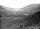
Corries indicate accumulation sites of glaciers, and Arran has numerous
good examples which confirms that the peaks in the northern granite were
sufficiently high to form a separate location of ice accumulation from
that on the mainland. The fact that there is significant change of topography
at approximately 750m in the northern granite has been taken by some scientists
as indicating the depth of ice - above 750m peaks such as Goat Fell and
Cir Mor are jagged and sharp, while lower peaks (again composed of granite)
are rounded. The jagged peaks may have stood out about the ice-sheet as
nunataks (being shattered by freezing and thawing) while the more rounded
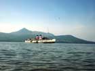
peaks were beneath the ice and being smoothes as it moved. Look carefully
at the image of Goat Fell shown above (with the Waverley in the foreground)
and you can see this feature. The image on the left also shows this feature
if you examine the profile of Goat Fell in the background. So
although the ice has gone, there is ample evidence of its former presence
on Arran, in the form of the raised beaches. There might be even more
specific information available from a study of the landscapes on Arran.
Corries indicate accumulation sites of glaciers, and Arran has numerous
good examples which confirms that the peaks in the northern granite were
sufficiently high to form a separate location of ice accumulation from
that on the mainland. The fact that there is significant change of topography
at approximately 750m in the northern granite has been taken by some scientists
as indicating the depth of ice - above 750m peaks such as Goat Fell and
Cir Mor are jagged and sharp, while lower peaks (again composed of granite)
are rounded. The jagged peaks may have stood out about the ice-sheet as
nunataks (being shattered by freezing and thawing) while the more rounded
peaks were beneath the ice and being smoothes as it moved. Look carefully
at the image of Goat Fell shown above (with the Waverley in the foreground)
and you can see this feature. The image on the left also shows this feature
if you examine the profile of Goat Fell in the background.
 Geological
boundaries (i.e. the contacts between different types of the rocks in
the field) also have major effects on the landscape. In the image on the
right, the prominent notch occurs along the line of the contact between
the northern granite on Arran (on the left) and the Dalradian rocks (on
the right). The granite is much younger, and has intruded into the crust
when hot, and caused local metamorphism in the much older Dalradian rocks
(see hornfels). This produces a zone of altered
rocks that weather more rapidly, leading to the feature we see today (more
details in description of the image on the right - click on it to read
about this). Geological
boundaries (i.e. the contacts between different types of the rocks in
the field) also have major effects on the landscape. In the image on the
right, the prominent notch occurs along the line of the contact between
the northern granite on Arran (on the left) and the Dalradian rocks (on
the right). The granite is much younger, and has intruded into the crust
when hot, and caused local metamorphism in the much older Dalradian rocks
(see hornfels). This produces a zone of altered
rocks that weather more rapidly, leading to the feature we see today (more
details in description of the image on the right - click on it to read
about this).
 Landslides
are another dramatic feature of the landscape controlled by underlying
geology. A major landslide has occurred on Arran in relatively recent
time, producing the 'fallen rocks' on the coast north of Corrie. Click
on image on left for more information. Landslides
are another dramatic feature of the landscape controlled by underlying
geology. A major landslide has occurred on Arran in relatively recent
time, producing the 'fallen rocks' on the coast north of Corrie. Click
on image on left for more information.
|